Krossá_tábořiště
Iceland, Þórsmörk, řeka Krossá, Langidalur | 370 m
Map
Objects around

There was found 2 objects if you know any other, try to add it here...
 Main informations


Notes
For this object is not here yet no note, so if you know something, try to add it here...
Photogallery
1
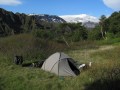
Pohled z tábořiště na ledovec Eyjafjallajökull s nedávno proslulou sopkou
© Kaja
(2012)
2
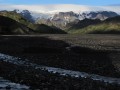
Pohled od tábořiště proti proudu Krossá na ledovec Mýrdalsjökull
© Kaja
(2012)
© www.boudy.info | all informations without guarantee | PHP 5.6.40-70+ubuntu20.04.1+deb.sury.org+1 | last change: 17.01.2022 19:41:24 V.A.